Archive for railroad

Nuttallburg, WV – Henry Ford’s Coal Experiment

Posted in Uncategorized with tags , , , , , , , , , , , , , , , , , , , , , , , , , , , , , , on September 23, 2012 by atomicimages

Restored Nuttallburg tipple.

Overview

Nuttalburg is a recent addition to the list of industrial sites that have been preserved by the National Park Service. There are countless sites that lie throughout the country on public land in various states of decay. Occasionally, places of historical significance are preserved for future generations to enjoy as a window into the past. Not too many years ago the coal tipple at Nuttallburg (used to load railcars) and its long conveyor structure stood silent and overgrown in the woods awaiting an eventual collapse from exposure to the elements, but thanks to an infusion of money and work from the park service it is now stabilized. The multi-year project wrapped up in 2011 and included stabilizing the tipple structure as well as clearing vegetation. The site was cataloged in 2005 and is listed on the National Register of Historic places; the park service states that it may be one of the most complete coal related industrial sites left in the United States. To appreciate the work that went into the project here is a photo of the tipple in its previous state.

Nuttallburg tipple before restoration.

Tipple structure was in great disrepair before being stabilized. Photo sourced from McMullan & Associates, Inc. , a structural engineering firm involved in the stabilization effort.

Early History

During the lifetime of the operation at Nuttallburg it had been operated by several different entities including Henry Ford’s Fordson Coal Company. The story of the complex begins way back in 1870, though, when an English-born man named John Nuttall saw opportunity in the deep New River Gorge area of West Virginia. He knew a new railroad was coming to the area and he also new coal was in the ground ready for the taking.  He began to buy up land in the area around the Keeney’s Creek drainage and when the Chesapeake & Ohio Railway (then under construction) reached the town it was ready to go. Nuttallburg became the second mining camp in the gorge to ship the area’s unique grade of “smokeless” coal in 1873. Business at the time was booming in the New River Gorge, around 50 separate mine towns and camps existed along both sides of the river pulling out the coal as fast as possible and feeding the northern industrial cities. John Nuttall passed away in 1893 but his town certainly did not die with him, the ownership passed to his heirs and the town continued to boom. Below is a comparison look at the tipple in it’s heyday as well as the current view.

Historic photo of the Nuttallburg tipple.

Nuttallburg tipple “back in the day.”

Modern day view of the tipple from the same perspective.

My modern day take on the same image. Alas, the roar of the tipple and the coal cars have long faded into history.

The Ford Era

In the year 1920 the Nuttallburg operation was leased and operated by none other than Henry Ford under the Fordson Coal Company. He had already revolutionized the automotive industry and was now out to apply his ideals to the bigger picture. The big idea in manufacturing in that day was the practice of “vertical integration,” a fancy term that basically means controlling the supply chain. To build Fords he had to have steel, lots of steel, and to make steel you had to have coal. Ford had already purchased steel mills to control his supply of metal to fabricate into cars, so his next logical step was to control the raw materials used in the steel making process. The purchase of Nuttallburg was really an experiment that lasted for eight years, and failed. A large amount of money was sunk into the mines to bring them up to “modern standards” of the day as well as the construction of the button conveyor system and the tipple that stands today. What can be seen when visiting the site is basically Ford’s legacy, with the exception of the coke ovens, which predated Ford’s leasing of the mines. They ceased operations in 1920 when Ford took over.

The failure came because of a force that could not be controlled by Ford, the railroad. He could not control it nor could he afford to buy it so it became a variable out of his control. Rail car shortages were rampant in the gorge with so many mines putting out coal there just wasn’t enough to go around and this frequently caused mine shutdowns. Also, an oppressive  amount of interchange regulations made shipping coal the long distance to Dearborn, MI a nightmare. After eight years Ford gave up the experiment and sold off the mines to the New River Mining Company, but left the facilities in much better shape than they found them. Production was greatly increased due to the modernization of the processes.

Post-Ford Nuttallburg

New River Mining renamed the mine Dubree #4 and operated it successfully until 1953. They sold off the facility to the Margie Coal Co. who quickly passed it off to Garnet Coal Co. who operated for four years but then shut down the mine for good in 1958 marking the end of Nuttallburg’s operational lifespan. There is a fair amount to see at the site, mostly remnants of the Ford era and beyond including the tipple and conveyor system, coke ovens (pre-Ford), overgrown railyard, lots of structure foundations and remnants, and the remains of a suspension bridge that once spanned the river.

Remnants of Nuttallburg train yard.

As a reminder of how nature can reclaim, this spaghetti bowl of rails used to be part of the tipple rail yard. Now trees thrive where coal cars used to be shuffled.

As a side note there is another piece to the operation up the hill I didn’t have time to visit that consists of the head house and mine portal itself. This is the top end of the conveyor system and is accessed at a different point than the Nuttallburg site itself. If you have info or images of the “top end” please contact  me and I will add them to the post with credit to you. The site is preserved as it is today because the family of John Nuttall gave the site to the National Park Service in 1998. The site was thoroughly cataloged for inclusion in the National Register of Historic Places in 2005 with restoration concluding in 2011.

How to Get There

Directions taken from the NPS website:

From Canyon Rim Visitor Center, go north on US 19 0.3 miles to the next intersection, and turn right onto Lansing-Edmond Road (County Route 5/82). Follow Lansing-Edmond Road (becomes CR 82) 6.0 miles to Winona. Turn right onto Keeney’s Creek Road (CR 85/2), continue past the houses (do not cross the creek) and the road turns to gravel. Travel 4.1 miles to the main Nuttallburg parking area and restroom. Parking for disabled visitors is located an additional 0.1 miles beyond the main parking area, closer to the tipple.

Winona can also be reached from the Canyon Rim Visitor Center by traveling north on US 19 to Hico 5.0 miles. Go east on US 60 (Midland Trail) 4.4 miles to Lookout, turn right onto Lansing-Edmond Road (CR 82) and go 2.1 miles to Winona, then follow the directions above for Keeney’s Creek Road (CR 85/2).

Headhouse access:

The easiest way to the headhouse area of Nuttallburg is located off Beauty Mountain Road near Lansing. From U.S. 19, take Lansing-Edmond Road (CR 5 becomes CR 82) 2.5 miles and turn right onto Beauty Mountain Road (CR 85/5). Travel 0.1 miles, then turn right onto the road just beyond Nuttall Cemetery Road. A parking area is located before the gated service road. Hike down the Headhouse Trail 0.5 miles to the headhouse area of Nuttallburg. Caution: this hike is steep and strenuous.

A Random Find

So, driving back out of Nuttallburg at the end of the excursion down the narrow, one lane gravel road I happened to look off down beside the road and saw a bridge hiding in the woods. It was cloaked in green, almost like camouflage, but I knew I had to get to it. It was covered in moss like some kind of ancient relic and I knew it had to be a piece of the infamous C&O Keeney’s Creek Branch.

View of trestle in the woods.

I spy…a railroad bridge. View from the road where I saw the bridge camouflaged in the woods.

After a short walk back down the road and over into the former roadbed I arrived at the end of the bridge. It was even prettier up close than it was from far away. I just can’t get over how green the scene was. Oddly, the outer rails (the ones the trains run on) have been removed but the inner rails (known as guard rails) were left intact. This puzzled me at the time, but today I saw a photograph of a car driving on one of the former Keeney’s Creek Br. bridges and I realized the outer rails were removed to facilitate automobile traffic at one time. Apparently, the railroad bed was the only way to reach this part of the gorge so once the branch shut down it became a road utilizing the existing bridges…mystery solved.

End view of the Keeney's Creek Branch bridge.

Nuttallburg is a gem of history thanks to the preservation efforts of the NPS and the gift of the site by the Nuttall family. The drive down into the gorge gets a bit long, but it is worth it in the end. If you find yourself at the northern end of the New River Gorge check it out!

Links of Interest

NPS Nuttallburg Brochure (PDF)

Coal Camp USA page on Nuttallburg (including mine photos)

Ghost of the O&W

Posted in Uncategorized with tags , , , , , , , , , , , , , , , , , , , , , on September 1, 2012 by atomicimages

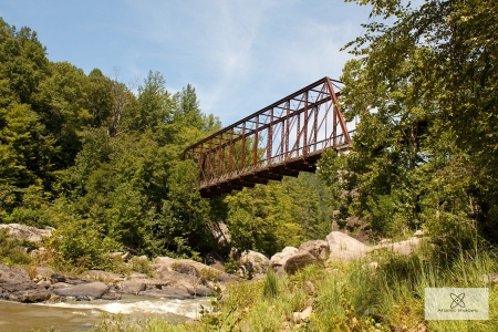
View of O&W Bridge from a rock in the river.

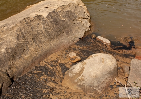
Some years ago I made a bucket list of abandoned structures around the east Tennessee area that I knew I wanted to get to and document. While many of these relics are in protected areas they are not getting any younger and someday they will be gone. The O&W bridge, located in the Big South Fork National River and Recreation Area, was pretty far down on the list but a couple Sundays ago I decided to hunt it down. I needed to get away for a while and a journey to the wilds of Scott County seemed like the thing to do. I have always had a love for Big South Fork and its rugged landscape, plus its not super crowded so one can visit in relative peace. Getting to the bridge requires an 8 mile drive down a potholed gravel road that adds to the charm, actually the current road is the former Oneida and Western Railroad mainline. It is narrow and winding like the railroad but it traverses some truly beautiful scenery. Upon reaching the bridge it is definitely worth checking out as it is a rare bird, one of few remaining Whipple through truss bridges. Besides the bridge, the area itself is a great place to spend an afternoon along the river with a few morsels of sandy beach to enjoy. Interesting to note is all the coal that can be seen along the waters edge often in fines or big rounded chunks that have been eroded away and washed downstream. Thanks to Teddy Huffmaster for insight into the coal in the river.

Coal deposits in the water's edge.

Coal deposits along the water’s edge from erosion of sedimentary layers.

Backstory of the O&W

The Oneida and Western Railroad (or just the O&W as it was known) operated from 1913-1954 and was one of two main railways that ventured into the virgin lands of what is now Big South Fork for the purpose of accessing the rich coal and timber reserves of the area. This gorge was tough to build a railroad into and required steep grades and many bridges to get at the resources. Upon its completion it ran from Oneida, TN to Jamestown, TN at a distance of approximately 30 miles and provided regular passenger service in addition to the numerous freight trains. For many of  the locals that lived and worked along the route the railroad was the only viable transportation in and out. Builders started in Oneida at the connection with the Cincinnati, New Orleans, Texas, and Pacific RR (CNO&TP), which today is part of Norfolk Southern,  and began grading west toward Jamestown and the Cumberland River. Two years later, in 1915, construction crews reached the edge if the Cumberland River and the Nashville Bridge Co. began constructing the all steel truss bridge that we examine in this article.

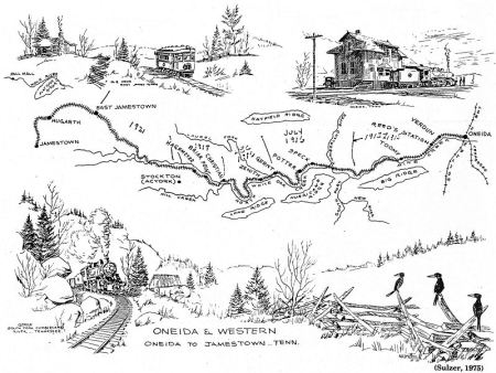
O&W map

A hand drawn map of the O&W route sourced from http://www.tngenweb.org. The bridge can be seen in the background of the lower picture to the right of the locomotive. Click the map for a larger view.

Work at the time was tough and earned a track layer 25 cents an hour in 1921. Continuing on past the river bridge, the railroad reached its destination at Jamestown in 1921 having conquered all the water crossings and large cuts, one as deep as 90 feet. Men of the day used mule teams to scrape and transport dirt in the shaping of the right-of-way, so think about that when driving the 8 miles of road that is truly the handwork of those men. 1930 saw the railroad wanting to extend the railroad another 7 miles to reach a large stand of timber at Jamestown leaving the final mileage 37.84. There were many “stations” along the relatively short railroad that included:

Station Name – Mile #
Oneida – 0
Verdun – 2
Reed’s Station – 3
Toomey – 6
Speck – 13
Potter – 14
Gernt – 16
Zenith – 17
Christian – 19
Briar Point – 20
Hagemeyer – 21
Stockton – 25
East Jamestown – 30
Jamestown – 37

The bridge design itself is rare in the regard that few survive today. Whipple through truss bridges were build in the period between 1847 and 1900, the only problem is this bridge was build in 1915…so that is 15 years too late right? Apparently, the bridge was salvaged from another rail line and brought to the site in pieces and rebuilt. The actual original build date for the bridge structure is unknown but older than 1915. I suppose it must have been cheaper to buy the salvage bridge than buy a new model, but this was somewhat common practice of the day. There are other bridges around east Tennessee that I know were used previously, two that come to mind are the Poplar Creek  Quadrilateral Warren through truss railroad bridge (relocated to serve the government’s K25 plant when built) and the Clinch River two-span Polygonal Warren through truss bridge (relocated on barges from west Tennessee) that carries the CSX railroad over Melton Hill Lake in Oak Ridge.

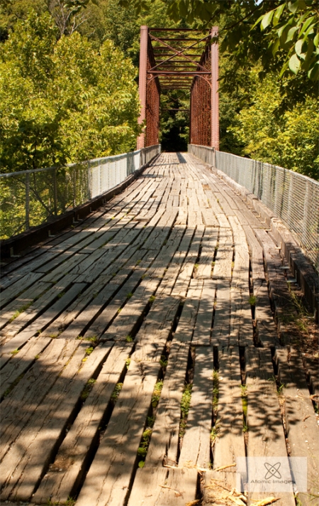
View of O&W bridge deck.

Deck view of the O&W bridge. Boards are widely spaced so careful walking and certainly do not ride a bike across. Bikes and horses should be walked across for safety. The sides have been fenced which is a good thing.

Exploring the Bridge Area

The bridge, though remote, is accessed by several trails and the road. It is one lane but plenty wide and we drove across with people standing on both sides with room to spare. To drive to the bridge from Oneida, TN headed south drive through the town on US 27 and turn right on 297 (or left if coming north) and then left on the aptly named O&W Rd. This road is decent and paved for a while, but eventually turns to gravel and crosses several one lane bridges. We passed a couple of passenger cars on the rough gravel section, but I really recommend a vehicle with larger tires to navigate the few ruts and numerous potholes. The drive is a little over 8 miles once you get on O&W Rd. but it is beautiful as the roadbed follows a wild creek down into the gorge and comes out alongside the Cumberland River.

If hiking, the most common path is from the trailhead at Leatherwood Ford. The O&W Bridge trail begins here and is roughly two miles one way to reach the bridge. This is a relatively easy hike with little elevation gain. The segment closest to the bridge is actually an incomplete planned extension of the railroad to Leatherwood Ford.

side bridge view

To access the lower sections of the bridge and the river a wide wooden staircase has been constructed on the east end of the bridge. Once reaching the bottom one can truly appreciate the river and get better views of the bridge in it’s natural environment. Just to the south of the bridge there is a sandy beach area that was a nice spot to relax and enjoy the sights and sound of the river for awhile. There are some rapids near the bridge (referred to as O&W rapids) that make for some pleasant river music. This is also a take out for kayaks, which may be the purpose for the large staircase. I’m not a kayaker so I admit this isn’t my field of expertise.

Overall, the bridge makes for a nice afternoon outing. You can check out the bridge, but also enjoy the wild river’s beauty. The 8 mile road to the site has plenty of beautiful scenery itself as it runs deep into the wild areas of Big South Fork.

Into the Dark – CNO&TP Tunnel No. 24

Posted in Uncategorized with tags , , , , , , , , , , , , , , , , on January 2, 2011 by atomicimages

I have a strange thing for large holes in the Earth. Mines, caves, tunnels; there is just something fascinating about being deep in the underground with tons and tons of rock above you. Tunnels are important to our modern transportation networks and we take them for granted with modern day tunnel boring machines and other precision equipment, but it wasn’t always that easy and sometimes it’s nice to reflect on the fact that men used to dig tunnels with sticks of dynamite and brute force. In fact the banner at the top of this page, if it displays correctly on your computer, is a testament to hand hewn tunnels. It is an image I took inside the next tunnel up the line, No. 23., and its rough cut nature. It is solid rock and was entirely blasted with dynamite, the subject of this post however was laid through softer ground and is brick lined.

The CNO&TP Backstory

This history sets the stage for this and other disused tunnels up and down the modern day CNO&TP that I have visited. Let’s begin by saying that there were once 27 tunnels but now the line only has three, a vast improvement for the railroads engineering department as tunnels are a pain in the butt to maintain. The tunnels that exist today are new (by new I mean built in the 60’s) except one which was simply enlarged. Over the years the line has undergone countless reroutes to bypass tunnels or generally improve the flow of the railroad. Today it is a hardcore line seeing 50+ trains in a 24 hour period and works as it was intended when it was started in 1869. Officially it is the Cincinnati, New Orleans and Texas Pacific Railway and is owned by the city of Cincinnati through a long term lease agreement with Norfolk Southern Corp. (formerly Southern Railway). It is the only long-haul freight railroad line in the U.S. that operates in this manner; the current lease expires in 2026. In this way it is considered a subsidiary of Norfolk Southern. Despite the name it does not run to Texas, New Orleans, or the Pacific but does originate in Cincinnati. It could be more correctly named the Cincinnati and Chattanooga as that is where it officially ends. It was once built to a gauge (width) of 5ft which is actually wider than today’s track but the tunnels were abandoned because they were too small for today’s trains, strangely ironic huh. The whole line was re-gauged to the current standard of 4ft 8½in. in 13 hours 1886 along with the rest of the country’s railroads. A number of the tunnels were bypassed during a wholesale elimination period between 1961 and 1963 including No.24.

Examining the Tunnel

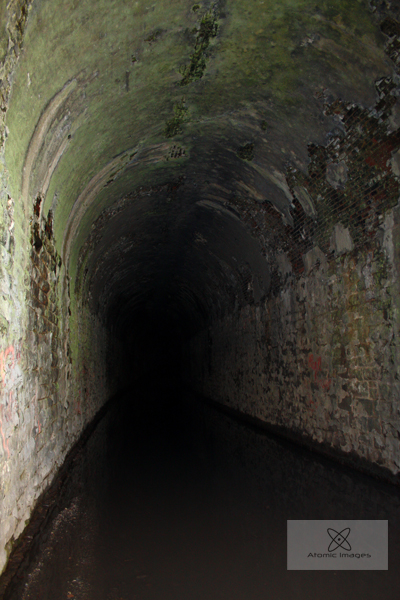
I have always loved trains and I have known about this location for a number of years as this area is a serene and scenic train watching spot. There were originally three tunnels here but now there are three abandoned and two active. Trains here sneak up on you and it’s as if they just come screaming out of the tunnels in a wave of diesel smoke.  I have visited plenty of times but this past October I came simply to visit the old tunnels as this one especially is decaying and won’t be around forever. They were built to last but nature always takes her toll and all of man’s creations eventually fall into ruin. No. 24 was completed around 1880 and is lined with stone and arched in brick, thousands of bricks. In fact, the bricks are several layers thick so lots and lots of brick laying was done upside down on the ceiling in a dark tunnel before electric lights.

Decaying north portal.

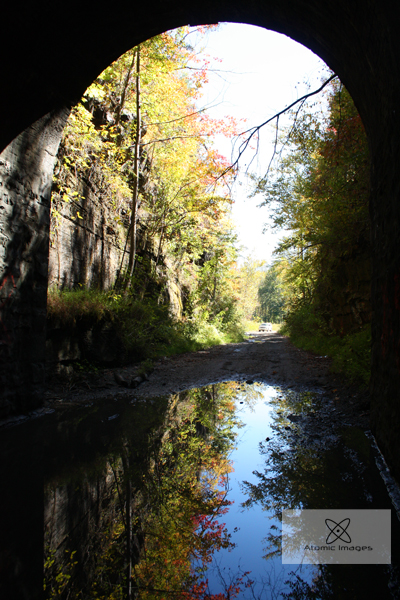
Some time later cement was spread over the bricks presumably to keep them from falling off the ceiling but it too has fallen away in places revealing the brick and making for a neat look. In the future I will post a few pics of No.23 separately along with other tunnels I have visited. This tunnel is located at Nemo, TN and is part of the Obed Wild and Scenic River. Nemo is a nice remote area between Wartburg and Catoosa and features a picnic area and a nice campground as well as hiking trails. There is also an old road bridge adjacent to the new one that you can walk out on over the river. I have always been fond of the Obed Gorge and its large rock cliffs.To get to Nemo take Catoosa Rd. out of Wartburg for a few miles until you rapidly descent down into the Gorge and come to the Nemo river bridge. To access the south portal turn left on a somewhat rough dirt road right before the river bridge and travel down past a kayak launch and some primitive campsites to the current railroad grade. If you look to the right and the leaves are off the trees you may see the decaying bridge abutment of the 21 mile long Morgan and Fentress RR which was destroyed by a large flood in 1929 and again in 1940 when it was finally abandoned. Nemo, meaning “no one” in Latin, was once a sizable town and was where the two railroads met prior to 1940. Anyway, the old tunnel is in a deep cut to the left of the new tunnel. The trains on this track come frequently so be careful and stay away from the tracks as they appear suddenly out of the tunnel. The south end is flooded with a foot or so of water depending on how wet it has been lately. Hearty souls in a high clearance vehicle can take a ride through the tunnel and yes the water is deeper in some spots but the tunnel dries out at the midway point and makes for an interesting trip. Just make sure you have your windows rolled up or you might get rather wet.

The north portal isn’t fairing as well as the south and looks as if it will fall off eventually. In places the portal is separated from the lining of the tunnel and you can see up above the lining. This end seems to have more ice around it in the winter which likely contributes to its poor condition. If you don’t feel up to the drive through the flooded tunnel there is another rougher road directly across the paved road you came in on originally that leads to the north portal and more primitive campsites as well as tunnel 23. It has some huge rocks and would be safer to hike than drive, and that comes from experience. This concludes our look at 24, an interesting artifact of a bygone day of railroading. More tunnels to come in the future. Nemo is certainly worth a visit just for the beauty of nature herself and hiking along the high bluffs with the river gurgling far below can’t be beat.

*****4/3/11 UpdateI just recently learned that the decaying north portal collapsed a few months back and the number stone is missing. this is a sad but expected development as the portal was already completely separated when I visited in October. I will return to get new pics as soon as I find the time.

A Study of the Tracks

Posted in Uncategorized with tags , , , , , , on November 22, 2010 by atomicimages

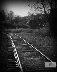
Lovely decaying tracks at Mead's Quarry.

Railroad tracks have always held a special place in my photographic heart. They exhibit perfect symmetry necessary to keep the trains on the rails; they are precision on a mass scale. This symmetry can be appealing as it leads your eyes very easily through the image.  But they also have another side, when they are seldom used they can be left to fall into terrible disrepair. Ties rot, railbeds sink, and the rails can bow out of gauge. The compression of a telephoto lens really enhances the dips in old tracks, especially track that is jointed and not continuously welded. Prior to the mid 2oth century all rail was produced in 39ft pieces (known as “stick rail”) so it could be easily transported to the worksite in the then standard 40ft gondolas. This type of rail is bolted together at the joints using four bolts and “fishplates” but over time with little or no maintenance the joints sag making a rough ride for train crews. Modern rail is continuously welded from the factory in quarter miles sections which are carried and laid at the worksite by special rail trains.

Rough jointed track, note the extreme wavy effect of the rails caused by bad joints and rotted ties. Needless to say I didn't stand too close as this thing rolled by me.

Railroads have a sense of history about them, they paved the way for the settlement of this country. You’ll often find them in the older, ruinous parts of town with all the interesting the buildings and the winos. They are one of my favorite industrial subjects for several reasons, but the tracks they run have an interesting story all their own. Especially on older branches or spur tracks the rail can be very old, I have seen some dated into the 20’s and 30’s still in service. That’s amazing considering the stress induced by trains running over it all the time. So next time you are out shooting don’t forget the trains (and tracks) hiding on the back side of town can be a subject all their own. Just remember to shoot from public property, roaming rail yards is a quick way to get arrested, many people don’t seem to realize that railroads are private property and walking the right-of way is trespassing. Happy shooting.

Old image from way back when I first got into photography. It's not so great but shows the perfect symmetry of the tracks on the Lower Twin Bridge at Weaver's Bend near the TN/NC state line.

Rankin Coaling Tower – A Memory of the Steam Era.

Posted in Uncategorized with tags , , , , , , , , , on November 14, 2010 by atomicimages

I visited this site several years ago but just tripped across it while trying to recatagorize my images. I first saw it standing in the background of a video clip on a commercial for the “Heartland Series”, a show on WBIR TV that showcases local history and people. I knew instantly that it looked like a railroad coaling tower but I was only aware of one other standing in east TN located along the CSX KD Sub. in Chaska, TN. This was obviously not that one as there was a lake in the foreground so I did some research and determined it was located near Newport along Douglass Lake (French Broad River) on a piece of bottom land sometimes inundated with water. With this knowledge I knew I would have to visit sometime in the winter when the lake levels were lowered.

One winter day while on the way to NC to check on dad’s farm we took a side trip to locate this structure. After following a plethora of winding back roads we came to a gravel road that led out into the Rankin Wildlife Area which was the home of this tower. It was obvious that most of this area is flooded a good part of the year ever since Dougless Dam was finished in 1943 to help supply power to Alcoa Aluminum and the Manhattan Project facilities in Oak Ridge. The current railroad grade runs several hundred feet west of the tower but originally ran under it until the line had to be raised due to the dam. A new bridge was also constructed higher up and the old one was torn down. The tower itself however is on higher ground and I don’t think the water ever touches it.

Southern RR Seal and date.

Few of these old towers remain as they had no function to the railroads after dieselization in the mid 20th century. This tower has a sign at the top that says it was built by the Roberts and Schaefer Company of Chicago who apparently built large numbers of these across the US in the early 1900’s. Of course the plate has been shot full of holes by bored rednecks.

Builder’s Plate

It appears that there was originally a conveyor running up the west side to the top to fill it with coal. A small building also stands on the west side at the base which could have housed machinery related to the function of the tower or have been an office, I’m not sure. Other than that the structure stands alone along the lake as a reminder of the romantic era of train travel when they were the only reliable was to travel long distances, breathed steam, and ate a steady diet of black diamonds.

K&T RR Arch Bridge – Yamacraw, KY

Posted in Uncategorized with tags , , , , , , , , , , on November 12, 2010 by atomicimages

My first encounter with this bridge was by accident two years ago while roaming southern Kentucky with my dad. We checked out Stearns and then ventured on into the Big South Fork area just looking around. It was December at the time and being that the trees were leafless he easily spied a large concrete structure down in the valley. After following roads that seemed to go in the right direction we came upon a small gravel pull-off and hidden by brush was the end of this beautiful bridge. It was one of those days when you aren’t looking for something and it just falls in your lap. Besides abandoned things my other love is trains and on that day I had been out to photograph them in the big cut at Keno, KY. Somehow though we found this and it made the whole day. Long story short my computer suffered a hard drive failure a year or two ago and I lost a lot of images that I’ll never get back, so back everything up people! I know we all hear that a lot but seriously, do it.

Under the bridge

Fast forward to two weekends ago, I found myself in Stearns again, this time on a mission to hit the restored mining camp at Blue Heron. Since Yamacraw is just north of there I decided what the heck, I might as we retake some pics of the old girl. Anyway, when I found this spot the first time I didn’t know its history at all, though it was obviously a railroad bridge. Why anyone would have built a huge five arch concrete bridge this far out on what was probably a logging or mining railroad baffled me. So when I got home that evening the first thing I did was some research, which didn’t turn up much. I did determine it was built by the Kentucky & Tennessee Railway in 1907, so it is fairly old to be in such good shape, and it’s a ballast-filled five arch concrete bridge. The Kentucky & Tennessee Railroad was established by the Stearns Coal and Lumber Co. (who also built Blue Heron) and incorporated in 1902. It was later determined that because of wording in the incorporation articles they couldn’t issue enough bonds to pay for expanding the line so it was re-incorporated in 1904 as the K&T Railway vs. Railroad in the previous name. Under the new incorporation they were then able to expand and build the bridge across the river at Yamacraw. At one time there was a company town of Yamacraw, though you wouldn’t know it today. I didn’t find any evidence of foundations or anything but the buildings were probably all wood and have long rotted into oblivion.

Bridge deck. It looks like someone has mowed it.

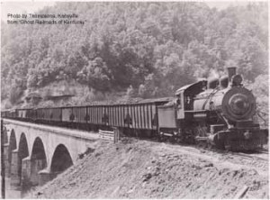
This line was once have happening place and saw many trains a day, including passenger service; it was not the dinky railroad I had envisioned at all. Interestingly, the website for the Big South Fork Scenic Railway which operated from Stearns to Blue Heron on the old trackage claims that the bridge is still in serviceable condition and they would someday like to re-lay the track across her, now that’s quality built! The last train crossed her in 1949 so that’s 60 years without maintenance. I have tried to determine the builder but so far I have come up short, I just can’t find much information on it. If you ever find yourself up Yamacraw way it’s worth stopping to pay your respects to this well-built piece of history.  I’ll leave you with a historic photo shot by Thomson of  Knoxville, this is a scanned image from the book “Ghost Railroads of Kentucky.”

In it’s heyday.

***Disclaimer***

I am not recommending that you walk out on this bridge. It is solid but is very high and has no side rails to keep you from falling the hundred feet or so onto the rocks below in which case you would be dead.  There is a trail down to the bottom to get nice views of the bridge but if you walk out onto the deck it is at your own risk. There is a well worn trail on the deck to the far side but I don’t like heights and have no idea whats over there. You have been warned…now go check it out!